Aerial imagery stories
Aerologix & Soar team up to create massive digital atlas
Mon, 30th Dec 2024
#
smart cities
#
bbc
#
aerial imagery
Aerologix and Soar have teamed up to launch the world's largest digital atlas, integrating over 36,000 drone pilots with 700,000 maps.
Picterra unveils GeoAI platform for plot monitoring
Tue, 19th Nov 2024
#
supply chain
#
clean technologies
#
sustainability
Picterra has unveiled Picterra Tracer, a GeoAI platform designed to enhance monitoring and compliance for soft commodities and forestry industries.
Nearmap reveals Gen 6 AI with 130 enhanced detections
Mon, 14th Oct 2024
#
smart cities
#
data analytics
#
ai
Nearmap has launched Generation 6 of its AI model, featuring over 130 location-based detections to enhance decision-making across various sectors.
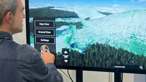
Nearmap reveals 'revolutionary' sixth-generation AI model using AWS
Thu, 11th Apr 2024
#
datacentre infrastructure
#
hyperscale
#
public cloud
Nearmap's sixth-gen AI model, developed with AWS, has slashed training time by a striking 98% and increased compute power up to forty times, enhancing precision in aerial imagery mapping.
Tech trio Carbonix, RIEGL & Phase One revolutionise aerial surveying
Tue, 5th Mar 2024
#
uc
#
digital twins
#
agentic ai
Leaders in drone technology, Carbonix, teamed with RIEGL and Phase One, to revolutionise aerial surveying and geospatial data acquisition, paving the way for efficient large-scale 3D terrain mapping.